Building a highly accurate digital twin of the Earth
Join DestinE's community
Destination Earth
Destination Earth is a flagship initiative of the European Commission to develop a highly-accurate digital model of the Earth (a digital twin of the Earth) to model, monitor and simulate natural phenomena, hazards and the related human activities. These groundbreaking features assist users in designing accurate and actionable adaptation strategies and mitigation measures.
DestinE unlocks the potential of digital modelling of the Earth system at a level that represents a real breakthrough in terms of accuracy, local detail, access-to-information speed and interactivity.
By pushing the limits of computing and climate sciences, DestinE is an essential pillar of the European Commission’s efforts towards the Green Deal and Digital Strategy.
How DestinE is used
DestinE supports tackling complex environmental challenges to:
- monitor and simulate the Earth’s system developments (land, marine, atmosphere, biosphere) and human interventions;
- anticipate environmental disasters and resultant socio-economic crises to save lives and avoid large economic downturns;
- enable the development and testing of scenarios for ever more sustainable development.
DestinE Platform
Access the unique ecosystem of services
and leverage the power of Destination Earth.
Destination Earth System
DestinE enables users to access thematic information, services, models, scenarios, simulations, forecasts and visualisations.
The main components of the DestinE system are:
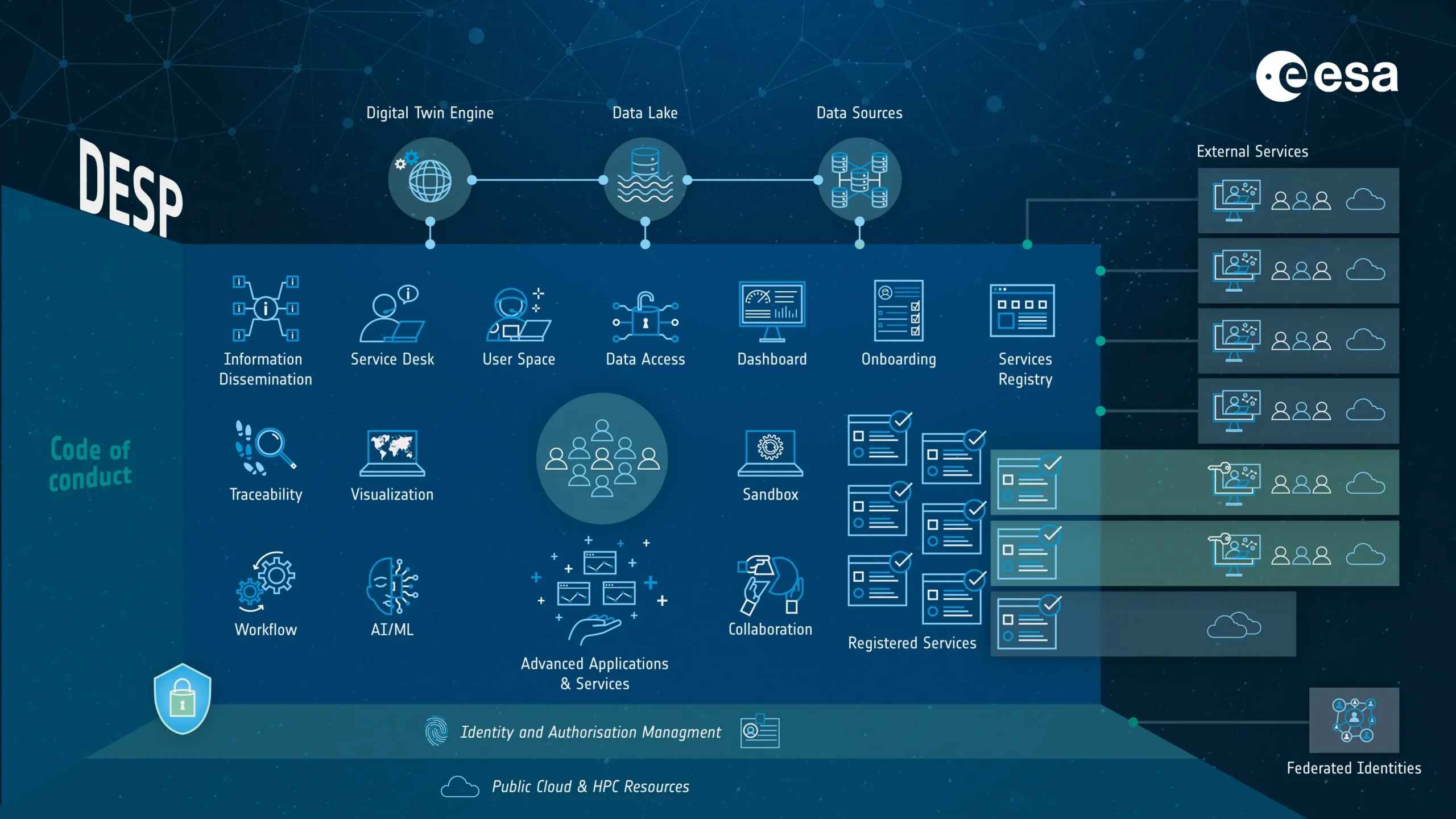
DestinE Platform
The platform provides evidence-based decision-making tools, applications and services, based on an open, flexible and secure cloud-based computing infrastructure. The platform is implemented by ESA.
Data Lake
The data lake brings together data from ESAEuropean Space Agency and EUMETSATEuropean Organisation for the Exploitation of Meteorological, as well as from Copernicus, and many other diverse sources, with new data from the Digital Twins. It allows discovery and data access as well as big data processing in the cloud. The Data Lake is implemented by EUMETSAT.
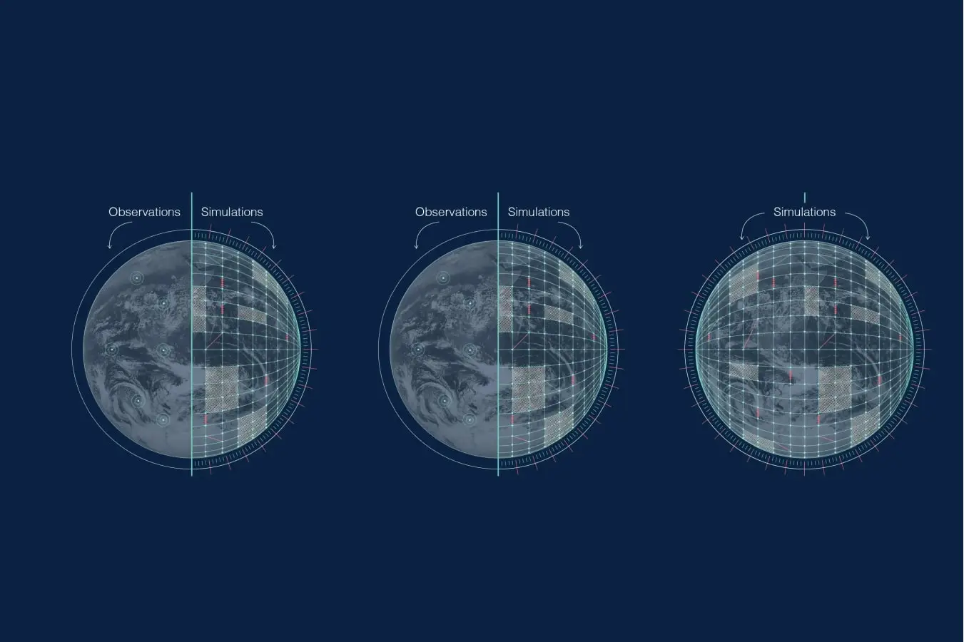
Digital Twins and Digital Twin Engine
DestinE is creating several digital replicas covering different aspects of the Earth system and based on state-of-the-art simulations and observations. ECMWFEuropean Centre for Medium-Range Weather Forecasts More is implementing the Digital Twin Engine, the complex software and data services needed for Earth System digital replicas, as well as the first two digital twins; Climate Change Adaptation, which provide multidecadal simulations, and the Weather-induced Extremes twin, with both high-resolution forecasts and on-demand simulations.
DestinE Timeline
DestinE is being developed through the following key milestones:
Official launch event of the initiative following the signing of the Contribution Agreements earlier in 2021.
Development of the main components begins.
All the components of the system (DestinE PlatformSelf-standing DestinE system component, interfacing with the More, Data Lake, Digital Twin Engine) have been developed. The DestinE PlatformSelf-standing DestinE system component, interfacing with the More and Data Lake have been transferred into operation. Demonstration of the first two digital twins on Weather-Induced Extremes and Climate Change Adaptation and the open core platform.
Further enhancement of the DestinE system and integration of additional digital twins and related services.
A "full" digital replica of the Earth
Who are DestinE’s Partners

European Commission
Leads and coordinates the implementation efforts among a core group of leading European organisations which will be responsible for developing the main elements of the initiative.
Read more

The European Space Agency ESAEuropean Space Agency
Responsible for the DestinE Open Core ServiceRegular provision of technological capabilities, resources, More Platform, the user entry to the DestinE SystemSystem composed of the Platform, the Data Lake, and the Digi More. Based on a multi-cloud infrastructure, the platform will provide access to data, applications and services.

European Organisation for the Exploitation of Meteorological Satellites
Responsible for the DestinE DataEarth-system monitoring and prediction system output as prov More Lake : built from geographically distributed physical elements, offering discovery & data access to a large data portfolio (Digital Twins data and more) and big data processing near data.